|
Very Low Frequency (VLF) Surveys
|
|
|
Groundwater resource studies
|
Mapping and plume delineation
|
|
Locating Fractures and Faults
|
|
Geological mapping
|
 |
|
VLF
|
Governments with naval forces have established a grid of tall, high powered transmitters, up to 1000 watts, that broadcast a signal field in the 15 to 28 kHz frequency range. These broadcast fields propagate thousands of miles over the Earths surface and are essentially uniform in the
atmosphere. Due to their power the signals penetrate into the ground to depths of several hundred feet. Because of the high material properties contrast at the ground/air interface, the signals are refracted down into the ground at steep angles. Since the Earth is relatively less homogeneous then the atmosphere, the EM flux crowds into zones of higher conductivity and rarefies in zones of higher resistivity. A VLF receiver tuned to the frequency of a VLF transmitter, traversed across the Earths surface, will exhibit high signals over conductive water
bearing fracture zone, for example, and a low strength signals over the resistive portions of the crystalline rock mass. Any linear conductive body, in addition to water bearing fractures, can also be detected by VLF methodology.
|
|
|
|
Data examples from a VLF geologic mapping survey
|
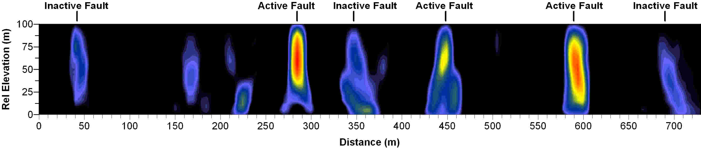
VLF profile collected near Fivemile Pass, Tooele County, Utah.Strike/slip faulting is abundant in this area with
a well established geologic history of tectonic quiescence and then sudden reactivation. Hotter colors represent
currently active faults while cooler colors indicate abandoned fault paths with reconsolidation of the fractures.
|
|
