Ground Penetrating Radar (GPR) Surveys
|
Locating buried tanks & drums |
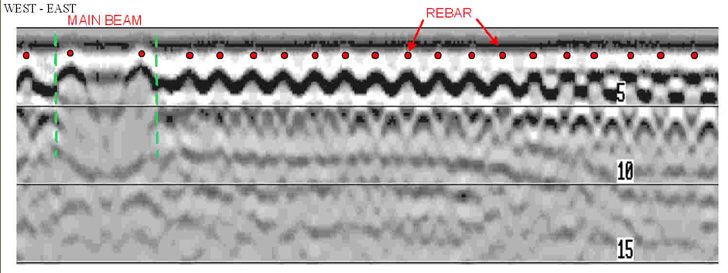
3D rebar mapping |
Locating underground utilities |
Mapping voids beneath pavement and/or behind retaining walls |
Measuring pavement thickness
|
Forensic investigations |
Archeological investigating |
Ground Penetrating Radar (GPR) is used to pinpoint the location of buried objects. Unlike conventional metal detectors, radar can locate both metal and nonmetal objects. It can also locate void spaces. A radar record provides a permanent detailed picture of the size, location and depth of an object.The GPR instrument beams energy into the ground from its transducer/antenna in the form of electromagnetic waves. A portion of this energy is reflected back to the antenna at any boundary in the subsurface, across which there exists an electrical contrast. The recorder continuously records an image of the reflected energy as the antenna is traversed across the ground surface. The EM wave travels at a velocity unique to the material properties of the ground being investigated and when these velocities are known, or closely estimated from ground conductivity values and other information, twoway travel times can be converted to depth measurements. Penetration into the ground and resolution of the image produced are a function of ground electric conductivity and dielectric constant. Images tend to be graphic, even at considerable depth, in dry sandy soils, but penetration and resolution is limited in drastically more conductive, moist clayey soil.